
24.1 miles with perhaps around 1100 feet of elevation gain (the elevation gain is plus or minus 200 feet...I can't tell for sure the way the contour lines are drawn on my map)
This was a day of mostly road walking and ATV-road walking. It was a nice change from all the overgrown snowmobile trails and muddy paths we had recently experienced. Also, the miles go quickly when one is walking these kinds of surfaces; we managed to cover 24 miles in about 7 hours.
First, though -- major props to the girls, for at this point, their shoes were wrecks. We opt for trail runners instead of hiking boots, and we had taken our chances on a new brand that, as you can see below, did not hold up under tough Cohos Trail circumstances.

Both girls' shoes looked like that, and yet they both hiked the remaining three days (about 70 miles) in them.
Back to the trail, which was mostly road --
The Databook makes everything clear as to where you need to go and when to turn, etc. I'll therefore let the photos do the talking in terms of scenery. We enjoyed this section very much; the trail may leave this area in the future and become actual trail, but I have to say that I like this bit as it is. It provides a nice change from the overgrown weeds and boot-sucking mud we had to contend with on so many of the previous sections.


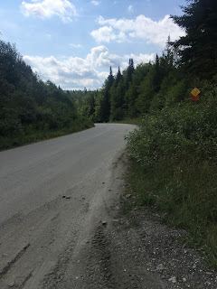
There were only two tedious parts of the day -- the first was the five mile road walk on Cedar Stream Road (after you turn right in the photo below)...

Cedar Stream Road felt like it went on forever, and there is little room to move out of the way for the giant logging trucks that sometimes thunder by, missing you by inches....


Also...the turn to the left to take you off Cedar Stream Road isn't clearly marked. We came across the post below...

...looked down the hill to the left, and saw a kiosk. We turned left here and yes, that was the trail down there, but the post above is not currently marked with a blaze. Therefore, pay attention to the Databook and keep your eyes pealed.
Once we descended, we soon found the bridges mentioned in the Databook...though one that was supposed to be unlocked was locked (we climbed over)...


The only remaining ornery part was Lake Francis Trail. This trail is overgrown and, at the end of a long day when you just want to get to your destination already, feels like it goes on and on and on and on.

Eventually it pops out onto Carr Ridge Road. The Databook is clear and we had no problems following the route from here to Young's Store/Happy Corners.


We had reserved a campsite at Mountain View Campgrounds, which is just across the street from Young's Store. Upon arrival, however, I discovered that with a $35 upgrade, we could get one of the small cabins for the evening. I opted for the cabin.
Mountain View Campground has wifi and cell service, FYI.

This was a day of mostly road walking and ATV-road walking. It was a nice change from all the overgrown snowmobile trails and muddy paths we had recently experienced. Also, the miles go quickly when one is walking these kinds of surfaces; we managed to cover 24 miles in about 7 hours.
First, though -- major props to the girls, for at this point, their shoes were wrecks. We opt for trail runners instead of hiking boots, and we had taken our chances on a new brand that, as you can see below, did not hold up under tough Cohos Trail circumstances.

Both girls' shoes looked like that, and yet they both hiked the remaining three days (about 70 miles) in them.
Back to the trail, which was mostly road --
The Databook makes everything clear as to where you need to go and when to turn, etc. I'll therefore let the photos do the talking in terms of scenery. We enjoyed this section very much; the trail may leave this area in the future and become actual trail, but I have to say that I like this bit as it is. It provides a nice change from the overgrown weeds and boot-sucking mud we had to contend with on so many of the previous sections.


There were only two tedious parts of the day -- the first was the five mile road walk on Cedar Stream Road (after you turn right in the photo below)...

Cedar Stream Road felt like it went on forever, and there is little room to move out of the way for the giant logging trucks that sometimes thunder by, missing you by inches....


Also...the turn to the left to take you off Cedar Stream Road isn't clearly marked. We came across the post below...

...looked down the hill to the left, and saw a kiosk. We turned left here and yes, that was the trail down there, but the post above is not currently marked with a blaze. Therefore, pay attention to the Databook and keep your eyes pealed.
Once we descended, we soon found the bridges mentioned in the Databook...though one that was supposed to be unlocked was locked (we climbed over)...


The only remaining ornery part was Lake Francis Trail. This trail is overgrown and, at the end of a long day when you just want to get to your destination already, feels like it goes on and on and on and on.

Eventually it pops out onto Carr Ridge Road. The Databook is clear and we had no problems following the route from here to Young's Store/Happy Corners.


We had reserved a campsite at Mountain View Campgrounds, which is just across the street from Young's Store. Upon arrival, however, I discovered that with a $35 upgrade, we could get one of the small cabins for the evening. I opted for the cabin.
Mountain View Campground has wifi and cell service, FYI.

We resupplied using Young's Store (they have everything you need and then some!), then spent the remainder of the day hanging out and resting our feet.
Two more days to Canada!
I will post again tomorrow evening (Happy Corner to Deer Mountain Campground).
My parents own a camp on Cedar Stream Road. Every summer it is so fun to see Cohos Trail hikers if we happen to see them when we are there.
ReplyDeleteUp until this point your schedule (ignoring zero days, and compensating for the time I took two intentionally short days instead of a zero) had been very similar to mine. However, what you did this day was a little more than two days hiking for me. I think you ended up with two less hiking days and two more total days.
ReplyDelete