
See the previous post for our morning hike from Baldface Lean-To to Dixville Notch.
16.7 miles with around 3000 feet of elevation gain (the entire day -- not just this second half)
Continuing on...
After lunch, we began the steepest climb of the day. The mile or so of trail from the parking area in Dixville Notch to the top of the cliffs is steep!

There are look-out points on the way up, which is nice...


We got to the top of the steep climb and turned right on the Sanguinary Summit Trail, which felt flat in comparison to what we had just hiked. From here, it was a gentle walk to the summit of Mt. Sanguinary.


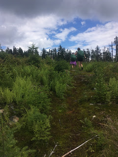
Summit!
From here, it was difficult to see where the blaze was on the other side of the clearing. It's straight ahead and to the left a bit. If you can't see it at first when you are there, step a few paces to the left and right until your eyes detect the yellow paint.


Now there's an 0.8 mile walk down to and through a lane before you turn onto another woods path...


From here, the Databook states it is 0.2 miles to Panorama Shelter. We really don't think this is correct; it feels much longer than 0.2 miles. Just keep following those blazes...there are times when you swear you aren't going the right way, but then a blaze will show up.

Panorama Shelter! We were just passing through, but we enjoyed hanging out here fore a few minutes. Our timing was good; a sudden and very brief downpour began right after we arrived. Just when we were ready to head out again, the rain ceased.

From here it was a quick 0.4 mile to Mud Pond Ridge...


...and then a grassy walk through a few skimobile trails (keep following the blazes).


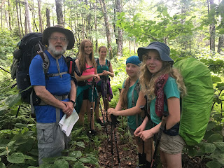
During this section, we saw our first Cohos Trail southbound thruhikers -- Misty (13), Annalee (12), and their grandfather Tom. It was so nice to see other people, and it was especially nice to see other kids on the trail.
Down we went...


The trail pops out on an old logging track road. From here, it's a scenic walk down to a red gate.


Near the gate is Sugar Hill Trail...

...which leads to Tumbledick Mtn Trail.
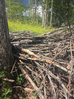
This is where things got tricky. There's logging going on around Tumbledick Mountain, so the trail seemed interrupted by stacked timber and recently cleared woods. We had to search carefully for blazes, and we often had to climb over obstacles.
In this maze, we met our second set of Cohos Trail southbounders -- a father and son named Karl and Aloysius (11). So great to see young people out doing thru-hikes!


We finally got through the fallen/logged tree area and continued on to the skimobile trail which leads into Coleman State Park.


The trail pops out right between two campsites at the park.

We were happy because we had been told the ranger's office closed at 6pm and it was 4:45 when we arrived. I had stored a resupply box filled with all kinds of goodies at the ranger station, and we were very much in the mood to eat most everything. We walked the couple tenths of a mile down the road to the ranger's office...

Alas, they had closed early! We had to make do with our sesame seeds until the next morning.
We had scheduled a rest day here, so we found our site (we rented the lean-to, which is huge and close to the lake), unpacked, then explored a bit.

Shower and laundry area (laundry!)...

Rec building...

We slept well that night. Here's a view of the lake from the lean-to as the sun set.

Here are some other shots of the lake and of our spacious lean-to...


Beginning Tuesday, I'll start posting about the last three days of our hike. Three days to Canada from here! Good times.
16.7 miles with around 3000 feet of elevation gain (the entire day -- not just this second half)
Continuing on...
After lunch, we began the steepest climb of the day. The mile or so of trail from the parking area in Dixville Notch to the top of the cliffs is steep!

There are look-out points on the way up, which is nice...


We got to the top of the steep climb and turned right on the Sanguinary Summit Trail, which felt flat in comparison to what we had just hiked. From here, it was a gentle walk to the summit of Mt. Sanguinary.


Summit!
From here, it was difficult to see where the blaze was on the other side of the clearing. It's straight ahead and to the left a bit. If you can't see it at first when you are there, step a few paces to the left and right until your eyes detect the yellow paint.


Now there's an 0.8 mile walk down to and through a lane before you turn onto another woods path...


From here, the Databook states it is 0.2 miles to Panorama Shelter. We really don't think this is correct; it feels much longer than 0.2 miles. Just keep following those blazes...there are times when you swear you aren't going the right way, but then a blaze will show up.

Panorama Shelter! We were just passing through, but we enjoyed hanging out here fore a few minutes. Our timing was good; a sudden and very brief downpour began right after we arrived. Just when we were ready to head out again, the rain ceased.

 |
| View from Panorama Shelter |
From here it was a quick 0.4 mile to Mud Pond Ridge...


...and then a grassy walk through a few skimobile trails (keep following the blazes).


During this section, we saw our first Cohos Trail southbound thruhikers -- Misty (13), Annalee (12), and their grandfather Tom. It was so nice to see other people, and it was especially nice to see other kids on the trail.

Down we went...


The trail pops out on an old logging track road. From here, it's a scenic walk down to a red gate.


Near the gate is Sugar Hill Trail...

...which leads to Tumbledick Mtn Trail.
This is where things got tricky. There's logging going on around Tumbledick Mountain, so the trail seemed interrupted by stacked timber and recently cleared woods. We had to search carefully for blazes, and we often had to climb over obstacles.
In this maze, we met our second set of Cohos Trail southbounders -- a father and son named Karl and Aloysius (11). So great to see young people out doing thru-hikes!


The trail pops out right between two campsites at the park.

We were happy because we had been told the ranger's office closed at 6pm and it was 4:45 when we arrived. I had stored a resupply box filled with all kinds of goodies at the ranger station, and we were very much in the mood to eat most everything. We walked the couple tenths of a mile down the road to the ranger's office...

Alas, they had closed early! We had to make do with our sesame seeds until the next morning.
We had scheduled a rest day here, so we found our site (we rented the lean-to, which is huge and close to the lake), unpacked, then explored a bit.

Shower and laundry area (laundry!)...

Rec building...

We slept well that night. Here's a view of the lake from the lean-to as the sun set.

Here are some other shots of the lake and of our spacious lean-to...


Beginning Tuesday, I'll start posting about the last three days of our hike. Three days to Canada from here! Good times.
I agree that the distance from Saguinary Mtn. to Panorama Shelter is much more than the 0.2 in the databook.
ReplyDelete